
Winter walks: waterfalls, mountains, castles and lakes
Twenty Boxing Day rambles featuring beautiful wintery British landscapes, stunning gardens and historic villages
1. Mawnan Cornwall
How hard is it? 4½ miles; some ups and downs on coast path. The National Trust looks after the stretch of coast that this walk explores. From Rosemullion Head you get fantastic views across the mouth of the Helford River. You skirt Mawnan Smith village before descending coastwards, turning through the gardens of Bosloe House and returning to Bosveal car park, from where beautiful Glendurgan Garden (open from February onwards) is a couple of minutes’ walk.
Map OS Explorer: 103; download walk/map atnationaltrust.org.uk/glendurgan-garden
Start Bosveal car park (NT: £2), Mawnan Smith, Falmouth TR11 5JR
The walk Footpath south to coast (775273): left (east) on coast path for 2 miles to Rosemullion Head (794280). Inland (west) via Rosemullion and Nansidwell farms; road (785280) into Mawnan Smith. Just beyond Carwinion Garden entrance (780283), left (south) on track for a good ½ mile. At valley bottom, right (780273) and follow path through Bosloe Garden to cross road (775275). Right to car park.
Lunch Red Lion, Mawnan Smith (01326 250026,redlioncornwall.com)
Getting there Bus: 35 (Falmouth-Helston); road: Glendurgan Garden/Bosveal car park signed from Mawnan Smith, 4 miles south of Falmouth via minor roads
More information nationaltrust.org.uk/glendurgan-garden;visitcornwall.com
2. Derwent Water and Lodore Falls Cumbria
How hard is it? 4 miles; easy lakeside walking.
Derwent Water is one of the Lake District’s most beautiful lakes at this time of year, and Lodore Falls makes a spectacular climax to the walk — “Thumping and plumping and bumping and jumping/And dashing and flashing and splashing and clashing,” as poet laureate Robert Southey once put it.
Map OS Explorer: OL4
Start ‘Theatre by the Lake’ car park, Keswick CA12 5DJ (OS ref NY 266229)
Finish Lodore Falls Hotel
The walk Go south along lake shore path for 2¾ miles to Kettlewell car park (267195). Cross B5289; follow signed footpath to falls (265185). Take main path down towards hotel; go left across stream (265188); through hotel grounds to B5289. Right to bus stop; in 100m, go left to the landing stage (264192).
Lunch Lodore Falls Hotel CA12 5UX (0800 8401246,lakedistricthotels.net/lodorefalls) or cafés in Keswick
Getting there Bus 554 (Carlisle), 555 and 556 (Lancaster, Carlisle) to Keswick. Road: M6 to Jct 40, A66 to Keswick
Getting back Bus 78 from stop opposite Lodore Falls Hotel
More information Keswick Tourist Information Centre (01768 772645, golakes.co.uk)
3. Horton to Fenwick, St Cuthbert’s Way Northumberland
How hard is it? 8½ miles; very well waymarked.
St Cuthbert’s Way runs from Melrose along the Scottish Borders and Cheviot Hills to Holy Island off the Northumbrian coast. This is one of the less demanding sections, a fine walk across the farmlands and through the woods of north Northumberland. St Cuthbert may not have stayed in the cave on this walk that bears his name, but it’s a beautiful place all the same.
Map OS Explorer: 340
Start East Horton, near Wooler NE71 6EZ, approx (OS ref NU 029308)
Finish Fenwick, on B6353, just off A1 — TD15 2PQ, approx (067401)
The walk Simply follow the waymarked St Cuthbert’s Way. In 4 miles, detour right to visit St Cuthbert’s Cave (059352). Climb path to left of cave; fork left at top to go over fence by stile; turn right to resume St Cuthbert’s Way.
Lunch Picnic
Getting there East Horton is signed off B6349, between Wooler and Belford
Getting back Ron’s Taxis of Wooler (01668 281281), or use two cars More information stcuthbertsway.info;visitnorthumberland.com/wooler
4. Gladhouse Reservoir, Lothian Scotland
How hard is it? 5 miles; easy roads and tracks.
Gladhouse Reservoir lies at the feet of the Moorfoot Hills, just south of Edinburgh. There are great prospects of the hills from this gentle ramble on minor roads and country tracks, and the chance of seeing merlin, plus wintering goldeneye, goosander and the handsome smew with its panda-black eyes and thin black streak markings on a snow-white body.
Map OS Explorer: 344, 345
Start Parking area, southwest corner of reservoir (OS ref NT 291528)
The walk Follow road/track past Moorfoot Farm and Huntly Cot. In another 500m, left through gate at track crossing, following grass track to Mauldslie Hill Cottage. From here follow road anticlockwise round reservoir, returning to parking area.
Lunch Picnic
Getting there 16 miles south of Edinburgh, turn left off A703 Peebles road at Waterheads on to minor road for 3½ miles to reservoir
More information walkhighlands.co.uk
5. Hooksway and Didling West Sussex
How hard is it? 6 miles; steeply down Didling Hill, steeply up Mount Sinai.
A stroll through gently rolling landscape, dotted with fine old country houses, where Hertfordshire marches with Bedfordshire. Hoo Wood and Marsh Wood are beautiful at any time of year, and the River Gade runs very clear in its chalk bed.
Map OS Explorer: 182
Start The Green at Jockey End HP2 6JD (OS ref TL 039137)
The walk Follow Hertfordshire Way for 2 miles southwest via Hoo Wood; cross A4146 and River Gade into Great Gaddesden. South through meadows for ¾ mile; cross River Gade and recross A4146. Follow Chiltern Way northeast for 2 miles via Marsh Wood to The Lane House; from here, field path northwest back to Jockey End.
Lunch Old Chequers, Gaddesden Row HP2 6HH (01442 256315,oldchequershemel.co.uk) — 1½ miles southeast of start
Getting there Jockey End is on a minor road between Markyate on A5 (M1, Jct 10) and Gaddesden (A4146)
More information chilternsociety.org.uk; Walk No 3 in the society’s 50 Great Walks in the Chilterns
6. The Gade Valley Hertfordshire
How hard is it? 5 miles; easy field paths.
A stroll through gently rolling landscape, dotted with fine old country houses, where Hertfordshire marches with Bedfordshire. Hoo Wood and Marsh Wood are beautiful at any time of year, and the River Gade runs very clear in its chalk bed.
Map OS Explorer: 182
Start The Green at Jockey End HP2 6JD (OS ref TL 039137)
The walk Follow Hertfordshire Way for 2 miles southwest via Hoo Wood; cross A4146 and River Gade into Great Gaddesden. South through meadows for ¾ mile; cross River Gade and recross A4146. Follow Chiltern Way northeast for 2 miles via Marsh Wood to The Lane House; from here, field path northwest back to Jockey End.
Lunch Old Chequers, Gaddesden Row HP2 6HH (01442 256315,oldchequershemel.co.uk) — 1½ miles southeast of start
Getting there Jockey End is on a minor road between Markyate on A5 (M1, Jct 10) and Gaddesden (A4146)
More information chilternsociety.org.uk; Walk No 3 in the society’s 50 Great Walks in the Chilterns
7. Tyrrels Wood and Morningthorpe Norfolk
How hard is it? 7 miles; flat woodland tracks and field paths, occasionally muddy. Some road walking.
The Boudicca Way threads ancient Tyrrels Wood, thick with evergreen holly and stands of hornbeam with branches as smooth as human limbs. Up north to Morningthorpe and Fritton with some beautiful cottages, then south again through a tangle of lanes. St Mary’s Church, Shelton, is a brick-and-flint beauty with striking medieval glass.
Map OS Explorer: 230, 237
Start Tyrrels Wood car park, Wood Lane, near Long Stratton IP21 4XU, approx (OS ref TM 206893)
The walk Follow Boudicca Way north through Tyrrels Wood and on for 2½ miles to Morningthorpe (216923). Road to Fritton (225926); south on Middle Road across Fritton Common and on past St Mary’s Church in Shelton (221910). In ¼ mile, right (220906) along Hall Lane, through Hardwick to Mill Lane (221894); right to Anson’s Lane (211895); left to Wood Lane (210892); right to car park.
Lunch Goodies Food Hall, French’s Farm, Wood Lane (01379 676880, goodiesfarmshop.co.uk)
Getting there Wood Lane runs east from the A140, two miles south of Long Stratton
More information woodlandtrust.org.uk
8. Far Ings Nature Reserve Lincolnshire
How hard is it? 2½ miles; easy shore and lakeside paths.
Make sure you take your binoculars — these former clay pits, now flooded, are a prime birdwatching site in winter. Stroll along the paths among the lakes and beside the 2-mile-wide River Humber, keeping your ears tuned for the whistle of wigeon and the piping of redshank, and your eyes peeled for big flights of pink-footed geese down from Iceland for the winter.
Map OS Explorer: 261 (download reserve walks map atlincstrust.org.uk)
Start Far Ings Nature Reserve Visitor Centre, Far Ings Road, Far Ings, Barton-on-Humber DN18 5RG (OS ref TA 018234)
The walk Follow Chowder Ness Round Path anticlockwise, with detours at will along the Reedbed Path to the east and/or Blow Wells and Target Lake Loop to the south.
Lunch George Inn, George Street, Barton-on-Humber DN18 5ES (01652 636303, thegeorgebarton.co.uk)
Getting there A1077 (“South Ferriby”) from A15 at south end of Humber Bridge; follow the brown tourist signs
More information Far Ings Nature Reserve Visitor Centre (weekends, bank holidays 10am-4pm; Weds 1pm-4pm) — 01652 637055, lincstrust.org.uk/far-ings-visitor-centre
9. Southstoke and Cam Valley Somerset
How hard is it? 5½ miles; a couple of short, sharp climbs.
Southstoke is gorgeous, a mellow tumble of Bath stone houses. Field paths descend through Horsecombe Vale to the old Somerset & Dorset railway path. From Midford you follow the snaking course of the long-disused Cam Valley Railway and the adjacent Somerset Coal Canal. It’s hard to believe this quiet, green part of the world was once a coalmining landscape.
Map OS Explorer: 155
Start Southstoke village, Bath BA2 7DU, approx (OS ref ST 747612).
The walk From church, east along road. Pass Southstoke House; left (fingerpost) across fields. Cross B3110. Descend Horsecombe Vale (yellow arrows/YA); cross brook; on to Tucking Mill Viaduct. Right along old railway to Midford station. Right to road; left through viaduct; cross B3110 (take care!); descend steps opposite Hope & Anchor PH (fingerpost); right along Cam Valley old railway and canal path for 2 miles to the Wheatsheaf inn, Combe Hay. Right beside inn, up lane for ¾ mile to road; right on path (fingerpost) to Southstoke.
Lunch Wheatsheaf, Combe Hay (01225 833504,wheatsheafcombehay.co.uk)
Getting there Southstoke is signed from B3110 between Combe Down and Midford
More information visitbath.co.uk
10. Stratford-upon- Avon to Welford, Warwickshire
How hard is it? 4¾ miles; good paths throughout.
A beautiful walk along the River Avon from Shakespeare’s home town, past Holy Trinity where he is buried, and out along a riverside path hedged with ripe sloes and rosehips. A cycle path along the old Cheltenham railway is followed by a stretch of the Avon River Walk by tiny All Saints Church at Weston, to Welford and the excellent Bell Inn.
Map OS Explorer: 205
Start Royal Shakespeare Theatre, Southern Lane, Stratford-upon-Avon CV37 6BB (OS ref SP 203548)
The walk Facing the theatre entrance, left to River Avon; cross canal, then river; right on footpath through recreation ground. Follow public footpath signs along river for 1¾ miles. Just beyond girder bridge, join cycle path (186532). Follow it to Chambers Crossing Halt (174523, marked); right for 100m to Apple Tree Cottage; left along Avon River Walk for 1¾ miles to Weston-on-Avon and Welford-on-Avon. Return — Bus 27, 28, 28A from bus stop on B439 at junction with Binton Road.
Lunch Bell Inn, Binton Road, Welford-on-Avon CV37 8EB (01789 750353, thebellwelford.co.uk)
Getting there Rail to Stratford-upon-Avon. Road: M40, Jct 15; A46 west to Stratford Park and Ride
More information Stratford-upon-Avon TIC (01789 264293)
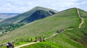
11. Mam Tor Derbyshire
How hard is it? 3 miles; hill paths, with some upward steps.
Fantastic views are your reward for a bit of effort as you climb the steps to the crown of Mam Tor. Stride the long ridge to reach Hollins Cross with great prospects north and west to Edale, south and east to Peveril Castle above Castleton. On the way back make time to explore the dramatic chambers of Blue John Cavern.
Map OS Explorer: OL1. Download map at nationaltrust.org.uk
Start Mam Nick car park, near Castleton, S33 8WA (OS ref SK 123832)
The walk Follow steps up to Mam Tor (128836) and on NE along ridge to Hollins Cross (136845). At monument, sharp right down to road at Mam Farm (133840). Follow rough road to Blue John Cavern (132832), then path south to Winnats Head Farm (131829). Path west, crossing road, to Windy Knoll Cave (126831 — no entry) and road to car park.
Lunch There’s plenty of choice in Castleton (2 miles from start point)
Getting there At top of Winnats Pass, 2 miles west of Castleton, turn right at T-junction; car park is two thirds of a mile on right
More information Castleton Visitor Information Centre (01629 816572, peakdistrict.gov.uk); Blue John Cavern: 9.30am to dusk daily except Dec 24-26 and Jan 1 (01433 620642; bluejohn-cavern.co.uk)
12. Moel Famau and Clwydian Hills North Wales
How hard is it? 5 miles; moderate.
An exhilarating stride on Offa’s Dyke Path along the ridge of the Clwydian Hills to the storm-shattered tower ruins on Moel Famau. Then steeply down and back along a path through sheltered sheep farms in the vale of Clwyd.
Map OS Explorer: 265
Start Bwlch Penbarras car park, Llanbedr-Dyffryn-Clwyd, LL15 1US approx (OS ref SJ 161606)
The walk Offa’s Dyke Path (ODP) north to Moel Famau (162626) and on. In two thirds of a mile, left off ODP (152630, fingerpost, yellow arrow/YA); descend path (marker posts) to Tyn-y-Celyn farm. Cross stream (143628); then sharp left (south) on path for 1¼ miles above Tyddyn Norbury, Bron-y-felin, Fron Goch and Fron Ganol to cross stream at Fron Bellaf (147612). From here, follow grass path climbing SE for two thirds of a mile to rejoin ODP (157608); right to car park.
Lunch Griffin Inn, Llanbedr-Dyffryn-Clwyd, LL15 1UP (01824 702792; robinsonsbrewery.com)
Getting there A494 from Mold towards Ruthin. In Llanbedr-Dyffryn-Clwyd, just before church, right up Lôn Cae Glas. Bear left along Lôn y Mynydd to Bwlch Pen Barras car park
More information Ruthin TIC (01824 703992)
13. Upper Arley and Wyre Forest Worcestershire
How hard is it? 7½ miles; easy, but may be muddy.
Green fields and the winding paths of the Wyre Forest are a prelude to the broad River Severn, where the steam locomotives of the Severn Valley Railway thunder across girder bridges.
Map OS Explorer: 218
Start The Harbour Inn, Upper Arley, Bewdley DY12 3NF (OS ref SO 765800)
The walk Pass Arley Station; in 500m, left off road; then paths southwest for 1½ miles via Pound Green to B4194 at Buttonoak (253780). Left for 250m (NB: keep to left-hand grass verge, take care!). Cross road at St Andrew’s Church (755779); right into Wyre Forest (yellow arrows), descending SSE to Dowles Brook. Left here (758768) on track for 1½ miles via B4194 (777763) to River Severn. Left for 3 miles to Arley.
Lunch The Harbour Inn, Upper Arley (01299 401204)
Getting there Rail: Severn Valley Railway (01299 403816; svr.co.uk) to Arley. Road: A456 to Bewdley, B4194 towards Kinlet; in Buttonoak, right (“Pound Green, Arley”). Follow “Arley footbridge” to car park
More information Bewdley TIC (01299 404740)
14. Slieve Gullion, Co Armagh N. Ireland
How hard is it? 8 miles; some climbing.
A superb walk, climbing to the summit lake, twin peaks and Neolithic passage grave of Slieve Gullion, with an enormous view over Northern Ireland and the Republic.
Map OSNI Discoverer: Sheet 29
Start Slieve Gullion Forest Park car park, Drumintee Road, Killeavy, Newry BT35 8SW (OS ref J 040196)
The walk (Ring of Gullion Way/RGW blue arrows.) From car park, left up path through trees. In a quarter of a mile join Forest Drive (038191) for a quarter of a mile to RGW post on left (035190). Right past metal barrier; left uphill for 1½ miles to car park (018200). Beyond picnic table, right (white post markers) steeply uphill. South Cairn (025203) — Lake of Sorrows — North Cairn (021211). Aim north for Sturgan Mountain, then white house between you and lake. Fork right at grassy “lawn” with boulder beyond, aiming for house. At road (025230), right for 3 miles to Forest Park (046199) and car park.
Lunch Picnic
Getting there Bus 43 from Newry. Road — From Newry, B113 (‘Forkhill’); in 3½ miles, right (“Slieve Gullion Forest Park”) to car park
More information 028 3086 1949, ringofgullion.org
15. Wootton Rivers and Pewsey Downs Wiltshire
How hard is it? 8½ miles; field paths, downland tracks, canal towpath.
A green lane from picturebook Wootton Rivers up to Mud Lane. An ancient trackway along the nape of the Wiltshire Downs, with amazing views across the Vale of Pewsey. Over the Iron Age hillfort of the Giant’s Grave; then down to the Kennet & Avon Canal.
Map OS Explorer: 157
Start Wootton Rivers village hall car park, near Marlborough, Wilts SN8 4NQ, approx (SU 197631)
The walk Footpath north for 1 mile to Mud Lane (198646); left (west) for 2 miles. At west end of Withy Copse, left (171642), following White Horse Trail south for 2½ miles via Giant’s Grave (166632) and Bethnal Green (161623) to Pains Bridge (165612). Left along canal for 2½ miles to Bridge 108/lock (198629); cross canal to car park.
Lunch Royal Oak pub, Wootton Rivers (01672 810322; wiltshire-pubs.co.uk)
Getting there Rail: Pewsey (two thirds of a mile from Pains Bridge). Bus: Bookable bus (08456 525255) from Pewsey to Royal Oak PH. Road: Wootton Rivers signposted off B3087 just east of Pewsey
More information Devizes TIC (01380 734669)
16. Habberley and The Hollies Shropshire
How hard is it? 5 miles; moderate, through up-and-down country.
The Mytton Arms in Habberley is named after Mad Jack Mytton, a splendidly roguish 19th-century squire who drank eight bottles of port a day and tried to leap a tollgate in a gig with four horses (the horses made it, Mytton didn’t). A beautiful walk through coppices and rolling country culminates in The Hollies, a very rare hollins, or cultivated holly wood jewelled with scarlet berries — if the mistle thrushes haven’t had them all.
Map OS Explorer: 216
Start Mytton Arms, Habberley, Shropshire SY5 0TP (OS ref SJ 399035)
The walk Right past church; 2nd left (‘Minsterley’); then bridleway (blue arrows) north into Lees Coppice. In 30m fork left; follow track; in 150 yards at T-junction, left (yellow arrows/YA) up steps, along wood edge. In 200 yards left (391044; “Chris Bagley Walk”/CBW) south, following footpath marked on map through Maddox’s Coppice to road end near Snailbeach (380022). Anticlockwise via Lordshill (381021), The Hollies (marked on OS Explorer — wander at will) and Upper Vessons Farm (387021), then NE back to Habberley.
Lunch Horseshoes Inn, Pontesbury SY5 0QJ (01743 790278, 2½ miles)
Getting there Habberley is signposted from Pontesbury on A488 (Shrewsbury-Bishop’s Castle)
More information Shrewsbury TIC (01743 281200)
17. Littleton- upon-Severn Gloucestershire
How hard is it? 5 miles; easy gradients, but can be very muddy.
A muddy path leads over undulating fields and through an old orchard to Cowhill. Ahead rises the tump where St Arilda’s Church stands proud. Beyond lies the muddy creek of Oldbury Pill, leading down to the River Severn.
Map OS Explorer: 167
Start White Hart, Littleton-on-Severn, Glos BS35 1NR (OS ref ST 596901)
The walk From White Hart, right to T-junction; footpath half-right to corner of wood (601905); NNE to Cowshill (607915). Road north past St Arilda’s to Anchor Inn (609924); left along Oldbury Pill, following Severn Way for 2¼ miles to Littleton Warth. Left up Rushen Lane (583907) on Jubilee Way to Littleton; left to White Hart.
Lunch White Hart (01454 412275, whitehartbristol.com)
Getting there M5 Jct 16; A38 north past Almondsbury; then Tockington, Olveston, Elberton, Littleton
18. Bennachie, Aberdeenshire Scotland
How hard is it? 6 miles; strenuous; steep climb to Oxen Craig.
This wonderful circuit takes you steeply up to the long ridge of Bennachie. Climb the four peaks of Little Oxen Craig and the 1,700ft peak of Mither Tap, steep and crowned with granite, where you’ll find the tumbled walls and gateway of a 2,500-year-old Pictish fort.
Map OS Explorer: 421
Start Back o’ Bennachie car park (£2), near Pitcaple, Inverurie, Aberdeenshire, AB52 6RH approx. (OS ref NJ 662246)
The walk Follow ‘Mither Tap Quarry Trail/MTQT’ signs for 3 miles via Little Oxen Craig (663232) and Oxen Craig (663227) to Mither Tap summit (682224). Return through fort gateway to path junction (683225). Follow ‘Bennachie Rowan Tree’ ahead. In ½ mile, left to summit of Craigshannoch (672232). Follow MTQT, then ‘Back o’ Bennachie’, back to car park.
Lunch Picnic
Getting there A96 from Inverurie towards Huntly; in 6 miles, left at Bridge of Carden on B9002. Half a mile beyond Oyne, left (‘Back o’ Bennachie’) to car park
More information Bennachie Centre (01467 681470);bailiesofbennachie.co.uk
19. Masham and Hackfall North Yorkshire
How hard is it? 7¾ miles; moderate, with some steep steps in Hackfall Woods.
From Masham, home of the Theakston and Black Sheep breweries, along the snaking River Ure to Hackfall, an 18th-century landscape of woods, water and follies, superbly maintained by the Woodland Trust.
Map OS Explorer: 298 and 302; also downloadable map leaflets (see below)
Start Masham Market Place, HG4 4DZ (OS ref SE 225807)
The walk From Masham follow waymarked Ripon Rowel Walk south for 3½ miles along River Ure into Hackfall Woods (235777). Follow “Riverside Rambler” walk to Fisher’s Hall (235772), then “Cascades & Follies” to car park on Thorpe Road (231775). Footpath west through Oak Bank woods, then (224776) north over Nutwith Common. Right up Thorpe Road (224782); in 250m, left along Roomer Lane; footpath (218790) past Low Swinton; road (215797) back to Masham.
Lunch White Bear, Wellgarth, Masham, HG4 4EN (01765 689319)
Getting there Bus: 138 (Ripon), 144 (Bedale). Road A1, Jct 50 (“A61, Ripon and Thirsk”), then follow signs to Masham (A6108)
More information woodlandtrust.org.uk
20. Sonning Eye and River Thames Oxfordshire
How hard is it? 5¾ miles; easy underfoot.
Up on to the ridge that overlooks the wide Thames Valley, then east across the fields and down to Shiplake College beside the river. A lovely snaking stretch of Thames-side walking leads to the beautiful village of Sonning, before returning to lunch in The Flowing Spring pub.
Map OS Explorer: 171
Start Flowing Spring, Henley Road, Oxon RG4 9RB (OS ref SU 746767)
The walk Cross A4155; path north to pass Binfield Heath Church (743779). In 200m, right (‘Shiplake’) on path via Shiplake Copse for 1¼ miles to road in Shiplake (762784). Right to cross A4155; down Church Lane, through Shiplake College car park to River Thames (767781). Right on Thames Path for 2 miles to Sonning Bridge (755758). Right along B478; in 200m, opposite French Horn, follow path to cross B478 (749761) and return to The Flowing Spring.
Lunch The Flowing Spring pub (0118 969 9878,theflowingspringpub.co.uk, closed Mondays).
Getting there The Flowing Spring is on A4155 between Caversham and Shiplake
More information Ramblers Festival of Winter Walks, until Jan 3:ramblers.org.uk/winterwalks